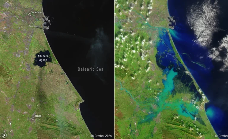
The deadly flooding that devastated parts of eastern Spain this week has left a stark and tragic mark on the landscape. Satellite images captured on October 30 reveal an inland sea where dry ground once stood, CCNN reports.
The area received a year’s worth of rain in just hours on Tuesday, triggering a surge of floodwater that overwhelmed rivers, turned streets into raging rapids, and washed away cars and bridges. The catastrophic event has claimed at least 155 lives, with dozens more still missing as rescue and recovery efforts continue.
The “before” and “after” satellite images provide a stark visual representation of the flooding’s scale. The once-familiar landscape, with its browns and greens, is now dominated by various shades of blue as floodwaters cover vast swathes of land. Coastal areas appear almost like islands amidst the sprawling expanse of water.
Even small waterways, barely noticeable in the earlier images, now appear as bright blue ribbons, showcasing the extreme swelling caused by the deluge. The impact is particularly evident in the area just south of Valencia’s city center, where a previously unremarkable waterway now stands out dramatically.
The torrential rainfall was not a random event. A rapid analysis by World Weather Attribution, conducted in the immediate aftermath of the disaster, found that the event was 12% heavier and twice as likely to occur now compared to a pre-industrial climate. This analysis provides strong evidence of the role climate change is playing in exacerbating extreme weather events.
In Chiva, located west of Valencia, a staggering 19 inches of rain fell in just eight hours on Tuesday, according to Spain’s meteorological agency, AEMET. This staggering amount of rainfall highlights the severity of the event and the urgent need to address the climate crisis.


