


A pair of winter storms are poised to deliver a one-two punch of snow, freezing rain, and dangerously cold temperatures to a large swath of the United States this week, NBC News reports.
As of Monday, over 96 million Americans were under winter weather watches, warnings, and advisories stretching from coast to coast.
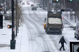
The first storm is expected to bring moderate snow from Kentucky to Maryland on Tuesday, with the mid-Atlantic region bearing the brunt of the snowfall. Forecasts predict 3 to 6 inches of snow for the area, with localized areas potentially receiving up to 8 inches. Washington, D.C., and Baltimore are bracing for 4 to 6 inches of snow accompanied by a glaze of ice, while Philadelphia could see 2 to 3 inches.
New York City’s Emergency Management Department issued a weather alert Monday, projecting 1 to 2 inches of snow on Tuesday and Wednesday, with some areas potentially receiving up to 4 inches.
In preparation, Washington, D.C. Mayor Muriel Bowser announced that the city’s snow team, equipped with 136 snowplows and 10 dump trucks, will begin pretreating roadways with snow-dissolving salt at midnight.
The southern edge of the storm system is expected to bring heavy rainfall across the South on Tuesday and Wednesday, with 1 to 3 inches of rain possible, and potentially higher amounts in some locations. The National Weather Service’s Weather Prediction Center has issued a slight risk of excessive rainfall over parts of the southern Plains and the lower Mississippi Valley, citing the potential for localized flooding. Cities including Shreveport, Louisiana; Jackson, Mississippi; Birmingham, Alabama; Atlanta; Knoxville, Tennessee; and Asheville, North Carolina are being monitored for possible urban flooding.
Accompanying the storms is a blast of arctic air, expected to bring temperatures 25 to 40 degrees below average across the northern Rockies and the northern High Plains. The National Weather Service in Boulder, Colorado, anticipates the arrival of the “main chunk of arctic air” on Wednesday, resulting in temperature highs in the teens. In Bismarck, North Dakota, forecasters are warning of life-threatening wind chills as low as minus 55 degrees Fahrenheit from Monday night into Tuesday morning.
The second storm is predicted to begin with light snow across Colorado, Nebraska, and Kansas on Tuesday night. By Wednesday, it will bring moderate to heavy snow from Kansas to Michigan, potentially impacting major metropolitan areas such as Kansas City, Missouri; Des Moines, Iowa; Chicago; Milwaukee; and Detroit.
Meanwhile, on the West Coast, a third storm system, a low-pressure system originating in the Pacific, is forecast to bring subtropical precipitation from Hawaii into California. Scientists at the Scripps Institution of Oceanography warn of potential flooding, mud flows, and debris flows in areas recently scarred by wildfires.
In response to the impending weather, Missouri Governor Mike Kehoe signed an executive order on Monday to help the state prepare. The order includes relaxed regulations for shipping residential heating fuels and authorizes the mobilization of the Missouri National Guard if necessary.