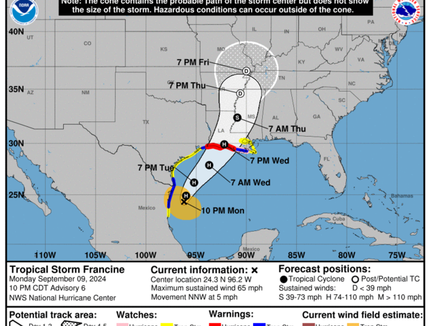
Tropical Storm Francine, currently churning through the Gulf of Mexico, is expected to strengthen into a hurricane and make landfall along the Louisiana coast on Wednesday, CBS News reports, citing the National Hurricane Center (NHC).
The storm, which was upgraded from a tropical depression to a named tropical storm on Monday morning, has been slowly crawling northwestward but is expected to pick up speed and intensity in the coming days.
As of 11 p.m. EDT Monday, Francine was located some 125 miles south-southeast of the mouth of the Rio Grande and 420 miles south-southwest of Cameron, Louisiana, moving at a slow pace of 5 mph with maximum sustained winds of 65 mph. This represents a significant increase from the 50 mph winds reported just three hours earlier, indicating the storm’s growing strength.
While Francine is still below the threshold to be considered a hurricane (74 mph winds), forecasters are predicting it will reach hurricane status before making landfall.
“Damaging and life-threatening hurricane-force winds are expected in southern Louisiana Wednesday, where a Hurricane Warning is now in effect,” the NHC announced on social media.
A Hurricane Warning has been issued for the Louisiana coast from Sabine Pass eastward to Morgan City, with a Hurricane Watch extending from Morgan City to Grand Isle. A Tropical Storm Warning is in effect for much of the Louisiana and Texas coastline, including the New Orleans area and Lake Pontchartrain, which is also under a Tropical Storm Watch.
Storm surge watches are in place from High Island, Texas, eastward to the border of Mississippi and Alabama, including Vermilion Bay, Lake Maurepas, and Lake Pontchartrain.
Forecasters warn that the combination of peak storm surge and high tide could result in significant flooding. Water levels could rise between 5 and 10 feet above ground level from Cameron to Port Fourchon, Louisiana, and around Vermilion Bay.
In addition to strong winds and potential flooding, Francine is expected to bring heavy rainfall to the region, with 4 to 8 inches forecast for coastal areas from northeastern Mexico to the southern and upper Texas coasts, and across southern Louisiana and southern Mississippi through Thursday morning. Certain areas could receive up to a foot of rain, leading to the risk of “considerable” flash flooding and urban flooding.
The storm’s projected path has shifted slightly eastward, with forecasters now predicting a landfall in Louisiana sometime on Wednesday. Earlier forecasts suggested a potential landfall in either Louisiana or eastern Texas. However, between Monday morning and early afternoon, the storm appeared to drift slightly east.


